Mt.Kai-komagatake (Kuroto-one)
Data
Max altitude: 2967m
Min altitude: 770m
Course distance: 16.2km
Course time: 12h05m
Overview of the mountain
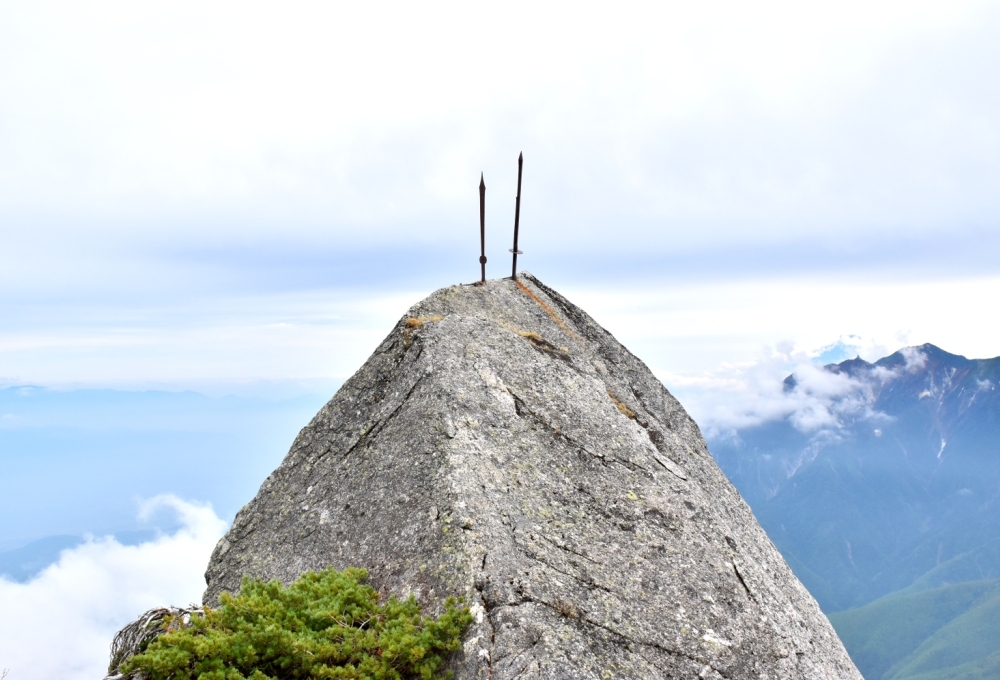
Kai-komagatake belongs to the Southern Japanese Alps, and its highest peak is 2967m above sea level.
"Kai" is the old name of Yamanashi prefecture and "Komagatake" means "the mountain of a horse".
That is because, when the snow on the mountain slowly begins melting in early summer, it emerges horse-shaped snow remaining on the surface of the mountain.
There are about 20 other Komagatakes in Japan for instance Aizu-Komagatake or Kiso-Komagatake, and Kai-Komagatake has the highest peak among them.
The snow-covered-like granite summit is the famous symbol of this mountain, and that white crown enhances grace and dignity.
Kai-komagatake is one of representing mountains in Japan so that it is listed in "Nippon Hyaku-meizan" (100 famous mountains in Japan) and "Nippon Hyakkei" (100 best sceneries in Japan).
This mountain has several approaching routes, and this time I chose Kuroto-one course which is notorious for long steep slopes (This is listed one of "The 3 steep mountaineering routes in Japan".).
So those who take this trail have to overcome the ascent dragging on over 8km and up 2200m vertical elevation.
Still, it isn't so hard for most of hikers who can prepare two days to conquer this mountain.
But this time I have to go back to my house on the same day to start trekking!
So I left my place by car in the midnight and took a short sleep at the parking in front of the trailhead.
By the way, I had three mistakes which made this journey long (Twelve hours!).
1: Having taken some unnecessary gears and worn relatively heavy shoes
2: Overpace
3: Having run short of foods, water and energy supplements
Note, this course isn't for beginners and you should prepare enough foods and mountain gears.
On the other hand, it is also important to reduce the weight of your accessories or you would be worn out in the early stages like me....
And more, you are supposed to submit your trekking plan sheets (English will be accepted.) in the box set in the beginning of the trail.
My visiting report: 28-May-2016, cloudy
At 5:00AM, we started trekking from the trailhead of "Chikuu-komagatake-jinja" shrine.
At 6:30AM, we arrived at "Sasanodaira-bunki" junction.
At 7:50AM, we passed "Hawatari" knifeledge.
At 8:50AM, we took a long rest at "Gogoume-koya-ato" the open space (the 5th station).
At 9:40AM, we arrived at "Shichijo-goya" hut.
At 10:50AM, we passed "Hachigoume-goraigo-jo" the open space (the 8th station).
At 0:10PM, finally we took the peak of Kai-Komagatake.
At 5:00PM, we somehow came back the trailhead.
How to access from Tokyo station
Train and Taxi
Tokyo stationChuo-line(Rapid)
Shinjuku station
Chuo-line(Ltd.Exp."Azusa")
Nirasaki station(*)
Taxi
The trailhead of Chikuu-komagatake-jinja
[Overall approximately 2h50m]
*Some Azusa pass Nirasaki station. In the case, you have an alternative to change to the local train at Kofu station where all Ltd.Exp. trains are supposed to stop.
Cars
Tokyo stationShuto expwy, Chuo expwy
Sutama interchange
Route612, 20 and nameless local roads
The trailhead of Chikuu-komagatake-jinja
[Overall approximately 2h20m]
Equipments you'd better prepare(if you intend to challenge the round-trip in a day)
Must-equipped
A mapTrekking shoes
A bottle of water (at least 2000ml but you can supply water at Shichijo-goya)
Foods (at least five rice balls and six energy gels)
Rain wears
Preferablly-equipped
A hatTrekking poles
Outfits against cold
A bear bell
+more activities
Ojiro-no-yu (a hot spring nearest from the trailhead)
Ojirogawa-keikoku (a gorge famous for clear water)
Michi-no-eki Hakushu (a shopping complex with a large car parking)